Jim Pearce, Webmaster, 3/28/07
Recognizing that this section is a work in progress, I decided to put it up on the website sooner rather that later, and let the Fair Oaks residents and authorities give some early feedback. Here we go!
(Note, 6/23/07 - We've re-started a project on old Fair Oaks homes, and are starting with a 1908 map and index to homes created by FOHS members. We've added the map to this section of the website, and would appreciate any help with unidentified structures.)
(Note, 4/21/07 - We've added two more maps that we found recently in the collection of Dr. Bramhall, the first doctor in Fair Oaks. Both are plot maps, 1897 and 1901, and each has some interesting features. Also, to facilitate returning to a particular map without going through the list in order, we've put an index of the maps at the bottom of this page.)
While researching issues of Fair Oaks history over the past year, we've come across over 20 different maps which include Fair Oaks (or where it would ultimately appear) ranging from 1880 to present. Some are beautiful, some are informative, and all are historically interesting. We'll describe the maps and their significance to Fair Oaks in the narrative. We encourage any corrections to our interpretations, and welcome information on other historic maps which we could include in this section.
The original maps are from several different sources, and we'll put a link to the original site with each map and credit the source. All source sites permit use of the maps for noncommercial purposes. The original maps are often in .pdf or .sid formats, both of which require a free add-on to your web browser, but add useful enhancements such as panning and enlarging. Pdf files require the Adobe Acrobat viewer which should already be on your computer. Sid files require the MrSid viewer which is available at Lizardtech
There are several preparatory things one must do before browsing the maps of Fair Oaks. The first is to locate the boundaries of Fair Oaks and the surrounding communities. This is not as easy as you might think, as Fair Oaks is not incorporated and its boundaries are defined by a number of special districts and agencies, all with slightly different boundaries. For reference, we'll use the zip code map from the postal service.
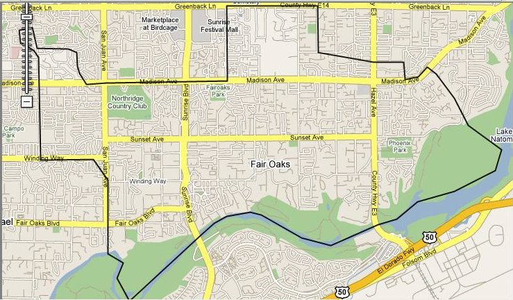
As we browse the old maps, it will sometimes be difficult to locate landmarks defining all of Fair Oaks. One helpful location is the backward "S" curve on the American River which leads to the San Juan rapids. If you can find that on the old maps, you can locate San Juan Avenue, and if you follow the general northward rise of the river to the east of the curve, about 2/3 of the way up the rise on the north of the river is the location of the old Fair Oaks town.
For those interested in other boundaries of Fair Oaks, Click here. Otherwise, let's go back to 1880
Quick jump to the maps: